Cloud Cover | Web Scraping Tool | ScrapeStorm
Abstract:Cloud cover (total cloud cover) refers to the proportion of the sky obscured by clouds, typically expressed in tenths or eighths (such as the "okta" scale used in meteorological observations). It is one of the fundamental elements in meteorological observation, reflecting the extent to which clouds obscure the sky at a given time or over a period. Observations of total cloud cover are typically conducted through visual estimation, ground-based meteorological instruments, or satellite remote sensing. Cloud cover directly affects the balance between incoming solar shortwave radiation received at the surface and downward longwave radiation from the atmosphere, making it a key parameter in regulating surface temperature, boundary layer development, and precipitation formation processes. Within climate systems and weather forecasting, cloud cover serves as an important variable connecting radiative processes with dynamic processes. ScrapeStormFree Download
ScrapeStorm is a powerful, no-programming, easy-to-use artificial intelligence web scraping tool.
Introduction
Cloud cover (total cloud cover) refers to the proportion of the sky obscured by clouds, typically expressed in tenths or eighths (such as the “okta” scale used in meteorological observations). It is one of the fundamental elements in meteorological observation, reflecting the extent to which clouds obscure the sky at a given time or over a period. Observations of total cloud cover are typically conducted through visual estimation, ground-based meteorological instruments, or satellite remote sensing. Cloud cover directly affects the balance between incoming solar shortwave radiation received at the surface and downward longwave radiation from the atmosphere, making it a key parameter in regulating surface temperature, boundary layer development, and precipitation formation processes. Within climate systems and weather forecasting, cloud cover serves as an important variable connecting radiative processes with dynamic processes.
Applicable Scene
Cloud cover data is widely used in weather forecasting, climate modeling, renewable energy assessment, agriculture, and environmental management. In numerical weather prediction (NWP) and climate models, total cloud cover is a core input parameter affecting the accuracy of radiative transfer calculations, surface energy budgets, and precipitation forecasts. In solar resource assessment, cloud cover directly determines the short-term fluctuations and long-term distribution characteristics of photovoltaic power generation potential. In agricultural meteorology, cloud cover is used to analyze frost risk, crop light conditions, and evapotranspiration estimation. In aviation and marine meteorology, cloud cover is also an important indicator for assessing meteorological conditions for flights and navigation. In satellite remote sensing inversion, cloud cover information is commonly used for cloud detection and cloud masking to ensure the accuracy of land surface parameter retrieval.
Pros: As the most direct indicator describing the extent of cloud coverage, cloud cover offers advantages such as a long observational history, diverse acquisition methods, and clear physical meaning. Long-term cloud cover observational data accumulated from ground-based meteorological stations provide valuable foundational data for studies on climate variability and long-term change. Satellite remote sensing enables global coverage and high spatiotemporal resolution monitoring of cloud cover, providing critical support for regional and global-scale weather and climate analysis. As a comprehensive cloud parameter, cloud cover effectively simplifies the description of clouds in radiative transfer processes, facilitating a balance between computational efficiency and physical realism in models. Furthermore, when combined with other cloud macroscopic and microscopic properties (such as cloud top height and cloud optical thickness), cloud cover can further enhance the characterization of radiative effects and precipitation processes.
Cons: The observation and definition of cloud cover involve certain subjectivity and uncertainty. Ground-based manual observations face challenges in accurately determining cloud cover conditions at night or under complex meteorological conditions, and judgment criteria may vary among different observers. While satellite remote sensing can provide large-scale cloud cover products, systematic biases often exist between different products due to influences from cloud detection algorithms, spatial resolution, and sensor viewing geometry. Additionally, total cloud cover, as a scalar indicator, cannot fully reflect cloud vertical structure, layering characteristics, or differences in cloud optical thickness. Therefore, in research and applications requiring detailed cloud vertical distribution information, relying solely on total cloud cover often proves insufficient. The discrepancy between the temporal cumulative effects of cloud cover and instantaneous observations also introduces uncertainty when matching cloud cover data with radiative processes.
Legend
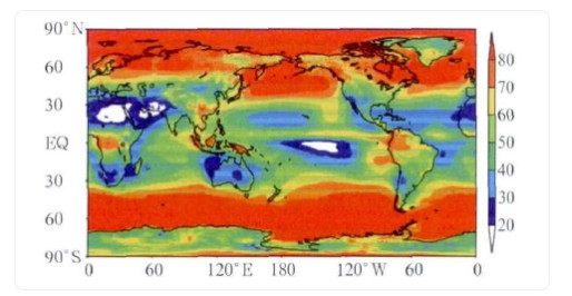
1. Global average total cloud cover distribution from 1979 to 2009.
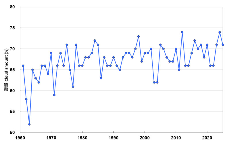
2. Average annual cloud cover recorded at the Observatory Headquarters (1961-2025).
Related Article
Reference Link
https://en.wikipedia.org/wiki/Cloud_cover
https://www.ventusky.com/total-cloud-cover-map
https://www.sciencedirect.com/topics/engineering/cloud-cover