Cloud Base Height | Web Scraping Tool | ScrapeStorm
Abstract:Cloud Base Height refers to the vertical distance from the ground to the bottom of a cloud layer. ScrapeStormFree Download
ScrapeStorm is a powerful, no-programming, easy-to-use artificial intelligence web scraping tool.
Introduction
Cloud Base Height refers to the vertical distance from the ground to the bottom of a cloud layer. It is an important meteorological element with significant relevance in aviation meteorology, weather observation, and remote sensing. Generally defined as the vertical distance from the ground to the lowest part of the cloud, its unit is typically meters (m) or feet (ft). Cloud base height is closely related to visibility, precipitation occurrence, and convective activity intensity, and therefore plays a critical role in aircraft takeoff/landing safety and weather forecasting. Common observation methods include ground-based equipment such as ceilometers, weather radar, and satellite remote sensing. Particularly in the aviation sector, cloud base height directly affects flight rule decisions and runway operations management, making accurate measurement and real-time updates essential.
Applicable Scene
Cloud base height is primarily applied in fields such as aviation meteorology, weather forecasting, climate research, and disaster monitoring. In aviation, by monitoring cloud base height around airports, pilots can determine whether to follow Visual Flight Rules (VFR) or Instrument Flight Rules (IFR). Additionally, airport operations management relies on cloud base height to determine whether flights can take off and land normally, as well as runway utilization efficiency, making real-time observation very important. In meteorological research, analyzing changes in cloud base height helps to better understand convection activity and precipitation formation mechanisms. Cloud base height is also an important parameter in urban meteorological studies and climate model validation. Researchers often combine satellite observations with ground-based observations to analyze atmospheric structure and cloud layer variations.
Pros: Cloud base height observational data provides important information for understanding atmospheric vertical structure. From an aviation safety perspective, accurately determining cloud layer height can significantly improve flight safety. At the same time, cloud base height can be used to predict convective activity and precipitation occurrence, thereby enhancing the accuracy of short-term weather forecasts. With the development of ceilometer technology and satellite remote sensing, cloud base height can now be observed over wide areas in real time, and this data can be utilized for meteorological analysis from urban to global scales. This information is of great significance for meteorological disaster warnings and environmental monitoring.
Cons: Measurements of cloud base height also have certain limitations. For example, ground-based observation equipment typically has a limited observation range, thus only obtaining data from local areas. When multiple cloud layers exist, different research or application scenarios may define “cloud base” differently, increasing the complexity of data interpretation. Furthermore, under conditions of dense fog or heavy precipitation, laser or optical measurement equipment may be interfered with, leading to reduced observation accuracy. Although satellite observations have wide coverage, factors such as cloud thickness and atmospheric conditions can introduce certain estimation errors, thus often requiring comprehensive analysis together with ground-based observation data.
Legend
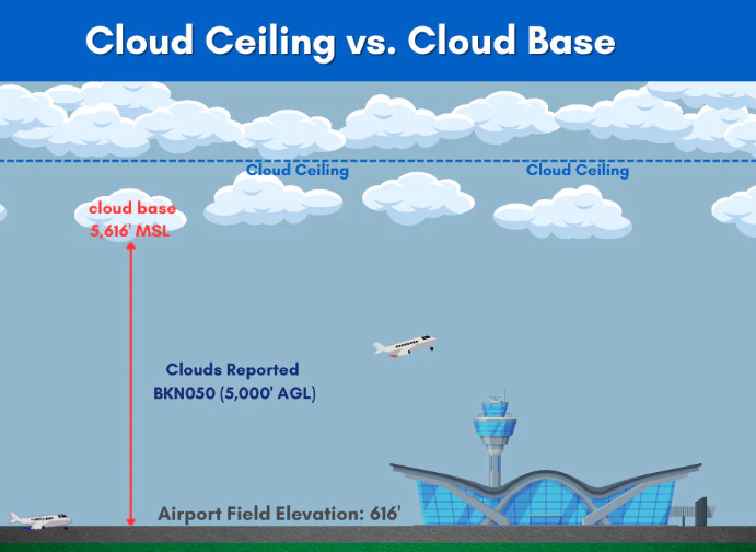
1. Cloud Ceiling vs. Cloud Base.
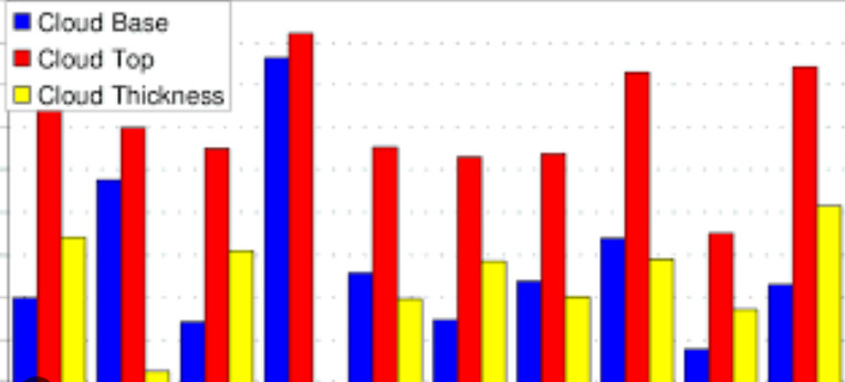
2. Average cloud base height, cloud top height, and cloud thickness.
Related Article
Reference Link
https://en.wikipedia.org/wiki/Cloud_base