Soil Moisture | Web Scraping Tool | ScrapeStorm
Abstract:Soil Moisture, typically expressed as Volumetric Water Content, refers to the volume of water contained per unit volume of soil, measured in cubic meters per cubic meter (m³/m³) or percentage (%). It is a core parameter describing soil water status and directly participates in surface energy balance, water cycle processes, and vegetation growth activities. Volumetric water content reflects the degree to which soil pores are filled with water, influenced by multiple factors including precipitation, irrigation, evaporation, transpiration, and soil permeability. It serves as a key indicator in agriculture, hydrology, meteorology, and environmental science. ScrapeStormFree Download
ScrapeStorm is a powerful, no-programming, easy-to-use artificial intelligence web scraping tool.
Introduction
Soil Moisture, typically expressed as Volumetric Water Content, refers to the volume of water contained per unit volume of soil, measured in cubic meters per cubic meter (m³/m³) or percentage (%). It is a core parameter describing soil water status and directly participates in surface energy balance, water cycle processes, and vegetation growth activities. Volumetric water content reflects the degree to which soil pores are filled with water, influenced by multiple factors including precipitation, irrigation, evaporation, transpiration, and soil permeability. It serves as a key indicator in agriculture, hydrology, meteorology, and environmental science.
Applicable Scene
Soil moisture is widely applied in agricultural irrigation management, drought monitoring, hydrological forecasting, climate modeling, and ecological environment assessment. In agriculture, it is used to determine crop water deficiency and guide precision irrigation, serving as an important basis for improving water use efficiency and ensuring crop yield. In hydrology, soil moisture influences rainfall-runoff formation processes and serves as a critical input parameter for flood forecasting and watershed water resource management. In meteorological and climate research, soil moisture affects regional temperature, precipitation, and atmospheric circulation by regulating surface evaporation and energy distribution, making it a key variable in land surface process models. Additionally, in remote sensing, soil moisture products retrieved from satellites enable large-scale, continuous soil water monitoring, supporting global change research and disaster early warning.
Pros: Soil moisture directly reflects the water status available for plant uptake, serving as an important bridge connecting meteorological conditions and agricultural production. Through in-situ observations or remote sensing retrieval, soil moisture data can be obtained at different spatial and temporal scales, supporting monitoring needs from field plots to global coverage. As a standardized indicator, volumetric water content facilitates comparative analysis across different soil types and regions. Furthermore, soil moisture provides early indications of drought development, offering significant warning value for agricultural disaster prevention and mitigation.
Cons: Accurate measurement of soil moisture is interfered by multiple factors including soil texture, structure, organic matter content, and temperature, with differences existing among various observation methods (such as oven-drying method, time domain reflectometry, and remote sensing retrieval). Its spatial and temporal variability is extremely high, significantly influenced by precipitation distribution, topography, and vegetation cover, making it difficult for single-point observations to represent regional average conditions. Although remote sensing retrieval offers wide coverage, its accuracy for shallow soil layers still faces challenges due to cloud cover, vegetation obstruction, and surface roughness effects. Additionally, the uneven distribution of long-term continuous observation stations limits the validation and application of high-resolution regional products.
Legend
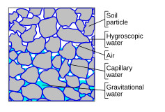
1. A soil-air matrix exhibiting gravitational, capillary and hygroscopic water.
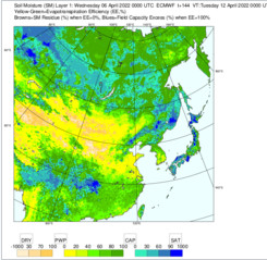
2. ECMWF soil moisture forecast for the East Asia region, showing the key moisture levels and intermediate measurements.
Related Article
Reference Link
https://en.wikipedia.org/wiki/Soil_moisture
https://earth.jaxa.jp/en/data/products/soil-moisture/index.html